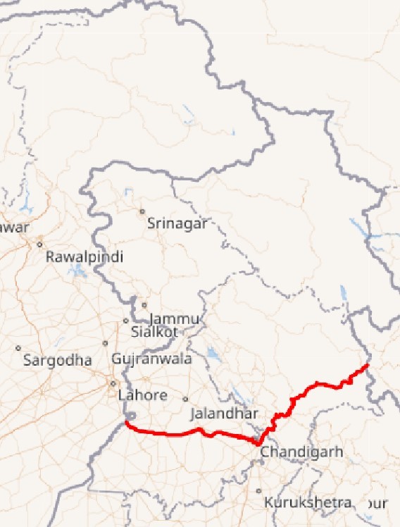
Connecting the country’s northern plains with the mountainous region of the Himalayas, National Highway 5 is one of the major highways in India. It runs from Firozpur in Punjab to Shipki La in Himachal Pradesh, covering three significant states and one Union Territory (UT). Interestingly, NH 5 offers commuters a unique glimpse into the geographical diversity throughout its route, along with providing seamless connectivity. So, let’s travel further and explore more about the NH 5 route map, distance, significance and the latest news in 2023.
About NH 5: Route map & entry-exit points
NH 5 covers a distance of 660.2 km and is maintained by the National Highways Authority of India (NHAI). Being an important national highway, National Highway 5 or NH 5 seamlessly connects the west with the east of the country. It runs from Punjab to Himachal Pradesh, covering Haryana and Chandigarh in between. If you want to enter NH 5, then you need to make the entry from Firozpur. To exit NH 5, you are required to do it at Shipki La in Himachal Pradesh.
Going into the details of the NH 5 route, after beginning at Firozpur, the highway enters Moga, Jagraon, Kharar and Ludhiana in Punjab, moving further towards Chandigarh, followed by Kalka in Haryana. It enters Himachal Pradesh in Solan, covering Shimla, Theog, Narkanda, Rampur, and Chini, proceeding towards the India-China border near Shipki La in Himachal Pradesh.
NH 5: Route Map
Source: Wiki Commons
NH 5: States covered
These are the states covered by NH 5
| States covered by NH 5 | Routes |
|---|---|
| Punjab | Firozpur (entry point), Moga, Jagraon, Ludhiana, Kharar and Morinda |
| Chandigarh | Mohali |
| Haryana | Panchkula, Surajpur, Pinjore and Kalka bypass |
| Himachal Pradesh | Parwanoo, Solan, Shimla, Theog, Narkanda, Kumarsain, Rampur Bushahr and Chini before reaching its terminus at Shipki La (exit point) |
 Could the article help you understand the topic?
NH 5: Significance
National Highway 5 is a lifeline for the people living in the hilly areas of Himachal Pradesh for their essential supplies such as food, fuel and medicines. It is also vital in providing access to some of the most strategic regions of the Indian Himalayas. NH 5 was first designated as a national highway in 1989. Before that, it was a part of the erstwhile NH 22 that ran from Ambala to Khab on the Indo-Tibetan border. It was only renumbered as NH 5 in 2010 as part of the National Highways Development Project (NHDP).
NH 5: Junctions
These are the major junctions of NH 5
| National Highway | Junctions of NH 5 |
|---|---|
| NH 354 | Firozpur |
| NH 354B | Firozpur |
| NH 54 | Talwandi Bhai |
| NH 105B | Moga |
| NH 703 | Moga |
| NH 44 | Doraha |
| NH 205 | Kharar |
| NH 205A | Kharar |
| NH 152 | Zirakpur |
| NH 7 | Zirakpur |
| NH 105 | Pinjore |
| NH 907A | Kumarhatti |
| NH 205 | Shimla |
| NH 705 | Theog |
| NH 305 | Sainj |
| NH 505A | Powari |
| NH 505 | Khab |
NH 5: Impact on Real Estate
With improved connectivity due to NH 5, there has been a surge in demand for property in the surrounding regions such as Moga, Ludhiana and Mohali, among others. This highway's accessibility has also attracted investors and homebuyers, leading to growth and an upward tick in land prices. Moreover, the growth in the commercial sector along this stretch also helped boost the demand for hospitality and retail properties. Overall, NH 5 played a vital role in the growth of the real estate market and changing the landscapes in the states connected.
See our latest webstory on Which highway links Haryana to Punjab? Find here!


